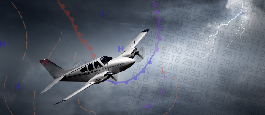
Aviation Routine Weather Report / Meteorological Aerodrome Report (METAR)
METARS (Meteorological Aerodrome Report) are aviation weather observations taken at designated reporting sites throughout the United States. They depict the actual current weather conditions at the reporting location. Normally the observation sites are located on airports, but occasionally outside of the airport boundaries. METAR observations are usually taken and transmitted hourly at about 50 minutes past each hour.
A SPECI (Special Weather Report) is a weather observation that updates a previous METAR (Meteorological Aerodrome Report) when there are significant changes in weather conditions that could affect flight operations. These updates are issued in between the regular METAR reports to ensure that pilots and other aviation personnel have the most current and relevant weather information. Here are some of the conditions that might trigger a SPECI:
- Significant changes in wind speed or direction
- Changes in visibility, especially when it drops below certain thresholds
- Onset, cessation, or change in the intensity of precipitation
- Changes in cloud cover, particularly the appearance or disappearance of low clouds or cumulonimbus clouds
- Occurrence of significant weather phenomena such as thunderstorms, tornadoes, or volcanic ash
- Changes in temperature or dew point that are significant for aviation operations
- Any other phenomena that could affect flight safety
SPECI reports follow the same format as METARs but are issued as needed rather than at regular intervals.
Although the METAR code is adopted worldwide, each country is allowed to make modifications or exceptions to the code for use in their particular country, e.g., the U.S. will continue to use statute miles for visibility, feet for RVR values, knots for wind speed, and inches of mercury for altimetry.
However, temperature and dew point will be reported in degrees Celsius.
The U.S. reports prevailing visibility rather than lowest sector visibility.
METAR Report Format
The elements in the body of a METAR report are separated with a space. The only exceptions are RVR, temperature and dew point, which are separated with a solidus ( / ).
When an element does not occur, or cannot be observed, the preceding space and that element are omitted from that particular report.
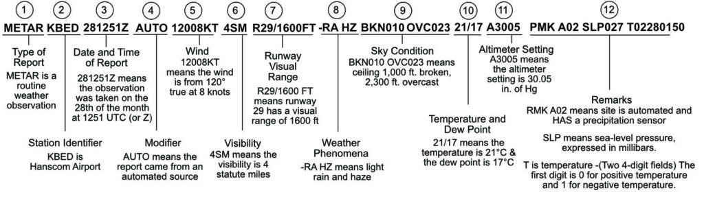
A METAR report contains the following sequence of elements in the following order:
- Type of report.
- ICAO Station Identifier.
- Date and time of report.
- Modifier (as required).
- Wind.
- Visibility.
- Runway Visual Range (RVR).
- Weather phenomena.
- Sky conditions.
- Temperature/dew point group.
- Altimeter.
- Remarks (RMK).
METAR Example
- Type of report—there are two types of METAR reports. The first is the routine METAR report that is transmitted every hour. The second is a special report, a SPECI, that can be given at any time there is a significant change to the weather reported in the previous METAR.
- Station identifier A four-letter code. This is, a unique three-letter identifier is preceded by the letter “K.”
For example, Hanscom Airport, is identified by the letters “KBED,” K being the USA country designation and BED being the airport identifier. - Date and time of report Depicted in a six-digit group (161753Z). The first two digits are the date, the 16th of the month, and the last four digits are the time of the METAR, which is always given in coordinated universal time (UTC), otherwise known as Zulu time.
- Modifier — denotes that the METAR came from an automated source or that the report was corrected. If the notation “AUTO” is listed in the METAR, the report came from an automated source. When the modifier “COR” is used, it identifies a corrected report sent out to replace an earlier report that contained an error
- Wind—reported with five numbers (12008), unless the speed is greater than 99 knots, in which case the wind is reported with six numbers. (if you see six numbers, you probably don’t want to be flying on that day!) The first three numbers indicate the direction from which the wind is blowing to the nearest ten degrees in relation to TRUE North. If the wind is variable, then “VRB” will go after the numbers. The last two digits indicate the speed of the wind in knots, unless the wind is greater than 99 knots, in which case it is indicated by three digits. If the winds are gusting, the letter “G” follows the wind speed numbers, and then the numbers right after G indicate the highest expected wind gusts (example = G26).
- Visibility—the prevailing visibility (4 SM) is reported in statute miles as denoted by the letters “SM.” It is reported in both miles and fractions of miles. for example ¾ of a mile.
- Runway Visual Range – the horizontal distance a pilot can see runway lights or markings from the cockpit while on the centerline. Used primarily for low-visibility takeoffs and landings, RVR is measured via sensors (transmissometers) near the runway, with values reported in feet (e.g., “1600”)
- Weather Phenomena —there are three parts to the weather section. The first is a qualifier of intensity. The intensity may be light (-), moderate ( ), or heavy (+). Because we’re seeing a – symbol, that indicates light. Then, if there’s any kind of weather phenomena that’s in the immediate vicinity of the airport, that’ll be shown.
If you happen to see a notation of “VC” in this section, that indicates a specific weather phenomenon is in the vicinity of five to ten miles from the airport. And then finally, the third part of this weather section are the descriptors, which are used to describe certain types of precipitation and obscurations.. - Sky condition — here we’re getting a sense of what cloud cover looks like. In this first part, we’re seeing the height of the cloud base, which is being reported with a three-digit number in hundreds of feet above-ground-level (AGL).
BKN stands for broken clouds, and “010” means 1000 feet. So the cloud base is at 1000 feet AGL. That’s one thing that’s happening.
OVC, stands for overcast, and the “023” stands for 2,300 ft. So we have overcast clouds at 2,300 ft. AGL. The type of cloud is reported here too. CB stands for cumulonimbus clouds, and another indicator you might see here is TCU, which stands for towering cumulus clouds. - Temperature and dew point —the air temperature and dew point are always given in whole degrees Celsius (°C) and separated by a forward slash (/). Temperatures below 0°C are preceded by the letter “M” to indicate minus.
- Altimeter setting—A3005 means that the altimeter should be set the altimeter pressure to 30.05 Hg, or inches of mercury.
- Remarks—the remarks section always begins with the letters “RMK.” Comments may or may not appear in this section of the METAR. The information contained in this section may include wind data, variable visibility, beginning and ending times of particular phenomenon, pressure information, and various other information deemed necessary. In the above example, PRESFR means “pressure falling rapidly”. Another example of a remark regarding weather phenomenon that does not fit in any other category would be: OCNL LTGICCG. This translates as occasional lightning in the clouds and from cloud to ground. Automated stations also use the remarks section to indicate the equipment needs maintenance.
(Note: When providing wind information to departing or arriving aircraft, Terminal facilities will provide winds relative to magnetic North).
Codes for descriptors and intensity indicators
| Intensity | Descriptor | Precipitation | Obscuration |
| (-) Light (No prefix) Moderate (+) Heavy | MI: Shallow BC: Patches DR: Low drifting BL: Blowing SH: Showers TS: Thunderstorm FZ: Freezing PR: Partial | DZ: Drizzle RA: Rain SN: Snow SG: Snow Grains IC: Ice crystals PL: Ice pellets GR: Hail GS: Small hail or Snow pellets UP: Unknown precipitation | BR: Mist FG: Fog FU: Smoke VA: Volcanic ash DU: Widespread dust SA: Sand HZ: Haze PY: Spray |
| Code | Meaning |
| SKC (Manual report) or CLR (Automated report) | Clear |
| FEW | Few (1/8 to 1/4 of the sky covered) |
| SCT | Scattered (3/8 to 1/2 of the sky covered) |
| BKN | Broken (5/8 to 7/8 of the sky covered) |
| OVC | Overcast (Total sky coverage) |
Weather Phenomena
The weather as reported in the METAR code is reported in the format:
- Intensity
- Proximity
- Descriptor
- Precipitation
- Obstruction to visibility
- Other
Intensity
Applies only to the first type of precipitation reported.
– denotes light,
no symbol denotes moderate,
+ denotes heavy.
Proximity
Proximity applies to and reported only for weather occurring in the vicinity of the airport (between 5 and 10 miles of the points) of observation.
It is denoted by the letters “VC.” (Intensity and “VC” will not appear together in the weather group).
Descriptor
These eight descriptors apply to the precipitation or obstructions to visibility:
TS: thunderstorm
DR: low drifting
SH: showers
MI: shallow
FZ: freezing
BC: patches
BL: blowing
PR: partial
Note: Although “TS” and “SH” are used with precipitation and may be preceded with an intensity symbol, the intensity still applies to the precipitation, not the descriptor.
Precipitation.
There are nine types of precipitation in the METAR code:
RA: rain
DZ: drizzle
SN: snow
GR: hail (1/4″ or greater)
GS: small hail/snow pellets
PL: ice pellets
SG: snow grains
IC: ice crystals (diamond dust)
UP: unknown precipitation (automated stations only)
Obstructions to visibility.
There are eight types of obscuration phenomena in the METAR code (obscurations are any phenomena in the atmosphere, other than precipitation, that reduce horizontal visibility:
FG: fog (vsby less than 5/8 mile)
HZ: haze
FU: smoke
PY: spray
BR: mist (vsby 5/8-6 miles)
SA: sand
DU: dust
VA: volcanic ash
Note: Fog (FG) is observed or forecast only when the visibility is less than five-eighths of mile, otherwise mist (BR) is observed or forecast.
Other.
There are five categories of other weather phenomena which are reported when they occur:
SQ: squall
SS: sandstorm
DS: duststorm
PO: dust/sand whirls
FC: funnel cloud
+FC: tornado/waterspout
Examples:
TSRA: thunderstorm with moderate rain
+SN: heavy snow
-RA FG: light rain and fog
BRHZ: mist and haze (visibility ⅝ mile or greater)
FZDZ: freezing drizzle
VCSH: rain shower in the vicinity
+SHRASNPL: heavy rain showers, snow, ice pellets
(intensity indicator refers to the predominant rain)
Sky Condition
The sky condition as reported in METAR represents a significant change from the way sky condition is currently reported. In METAR, sky condition is reported in the format:
- Amount
- Height
- (Type) or Indefinite Ceiling
- Height
Amount.
The amount of sky cover is reported in eighths of sky cover, using the contractions:
SKC: clear (no clouds)
FEW: >0 to 2/8
SCT: scattered (3/8s to 4/8s of clouds)
BKN: broken (5/8s to 7/8s of clouds)
OVC: overcast (8/8s clouds)
CB: Cumulonimbus when present
TCU: Towering cumulus when present
Notes:
“SKC” will be reported at manual stations. “CLR” will be used at automated stations when no clouds below 12,000 feet are reported.
A ceiling layer is not designated in the METAR code. For aviation purposes, the ceiling is the lowest broken or overcast layer, or vertical visibility into an obscuration. Also there is no provision
for reporting thin layers in the METAR code. When clouds are thin, that layer must be reported as if it were opaque.
Height
Cloud bases are reported with three digits in hundreds of feet above ground level (AGL). (Clouds above 12,000 feet cannot be reported by an automated station).
(Type) or Indefinite Ceiling
If Towering Cumulus Clouds (TCU) or Cumulonimbus Clouds (CB) are present, they are reported after the height which represents their base.
Example:
(Reported as) SCT025TCU BKN080 BKN250
Vertical Visibility (indefinite ceiling height).
The height into an indefinite ceiling is preceded by “VV” and followed by three digits indicating the vertical visibility in hundreds of feet. This layer
indicates total obscuration.
Example:
1/8SM FG VV006- visibility one eighth, fog, indefinite ceiling six hundred.
Obscurations are reported when the sky is partially obscured by a ground-based phenomena by indicating the amount of obscuration as
- FEW
- SCT
- BKN
followed by three zeros (000). In remarks, the obscuring phenomenon precedes the amount of obscuration and three zeros.
Example:
BKNO00 (in body): “sky partially obscured”
FU BKNO00 (in remarks): “smoke obscuring five- to seven-eighths of the sky”
When sky conditions include a layer aloft, other than clouds, such as smoke or haze the type of phenomena, sky cover and height are shown in remarks.
Example:
BKN020 (in body): “ceiling two thousand broken”
RMK FU BKNO20: “broken layer of smoke aloft, based at two thousand”
Variable ceiling. When a ceiling is below three thousand and is variable, the remark “CIG” will be shown followed with the lowest and highest ceiling heights separated by a “V.”
Example:
CIG 005V010: “ceiling variable between five hundred and one thousand”
Second site sensor.
When an automated station uses meteorological discontinuity sensors, remarks will be shown to identify site specific sky conditions which differ and are lower than conditions reported in the body.
Example:
CIG 020 RY11: “ceiling two thousand at runway one one”
Variable cloud layer. When a layer is varying in sky cover, remarks will show the variability range. If there is more than one cloud layer, the variable layer will be identified by including the layer height.
Example:
SCT V BKN: “scattered layer variable to broken”
BKN025 V OVC: “broken layer at two thousand five hundred variable to overcast”
Significant clouds.
When significant clouds are observed, they are shown in remarks, along with the specified information as shown below:
(1) Cumulonimbus (CB), or Cumulonimbus Mammatus (CBMAM), distance (if known), direction from the station, and direction of movement, if known. If the clouds are beyond 10 miles from the airport, DSNT will indicate distance.
> Example:
CB W MOV E: “cumulonimbus west moving east”
CBMAM DSNT S: “cumulonimbus mammatus distant south”
(2) Towering Cumulus (TCU), location, (if known), or direction from the station.
Example:
TCU OHD: “towering cumulus overhead”
TCU W: “towering cumulus west”
(3) Altocumulus Castellanus (ACC), Stratocumulus Standing Lenticular (SCSL), Altocumulus Standing Lenticular (ACSL), Cirrocumulus Standing Lenticular (CCSL) or rotor clouds, describing the clouds (if needed) and the direction from the station.
Example:
ACC W: “altocumulus castellanus west”
ACSL SW-S: “standing lenticular altocumulus southwest through south”
APRNT ROTOR CLD S: “apparent rotor cloud south”
CCSL OVR MT E: “standing lenticular cirrocumulus over the mountains east”
Temperature/Dew Point.
Temperature and dew point are reported in two, two-digit groups in degrees Celsius, separated by a solidus (“*”). Temperatures below zero are prefixed with an “M.” If
the temperature is available but the dew point is missing, the temperature is shown followed by a solidus. If the temperature is missing, the group is omitted from the report.
Altimeter.
Altimeter settings are reported in a four-digit format in inches of mercury prefixed with an “A” to denote the units of pressure.
Example:
A2995: “Altimeter two niner niner five”
Remarks.
Remarks will be included in all observations, when appropriate. The contraction “RMK” denotes the start of the remarks section of a METAR report.
Except for precipitation, phenomena located within 5 statute miles of the point of observation will be reported as at the station.
- Phenomena between 5 and 10 statute miles will be reported in the vicinity, “VC.”
- Precipitation not occurring at the point of observation but within 10 statute miles is also reported as in the vicinity, “VC.”
- Phenomena beyond 10 statute miles will be shown as distant, “DSNT.”
- Distances are in statute miles except for automated lightning remarks which are in nautical miles.
- Movement of clouds or weather will be indicated by the direction toward which the phenomena is moving.
There are two categories of remarks:
- Automated, manual, and plain language.
- Additive and automated maintenance data.
Automated, Manual, and Plain Language remarks may be generated from either manual or automated weather reporting stations and generally elaborate on parameters reported in the body of the report.
(Plain language remarks are only provided by manual stations).
Plain Language remarks may be provided for:
- Volcanic eruptions.
- Tornado, Funnel Cloud, Waterspout.
- Station Type (AO1 – automated station without precipitation discriminator, or AO2 automated station with precipitation discriminator)
- PK WND.
- WSHFT (FROPA).
- TWR VIS or SFC VIS.
- VRB VIS.
- Sector VIS.
- VIS @ 2nd Site.
- Lightning. When lightning is observed at a manual location, the frequency and location is reported.
When cloud-to-ground lightning is detected by an automated lightning detection system, such as ALDARS:
- Within 5 nautical miles (NM) of the Airport Reference Point (ARP), it will be reported as “TS” in the body of the report with no remark;
- Between 5 and 10 NM of the ARP, it will be reported as “VCTS” in the body of the report with no remark;
- Beyond 10 but less than 30 NM of the ARP, it will be reported in remarks as “DSNT” followed by the direction from the ARP.
Example: LTG DSNT W or LTG DSNT ALQDS
- Beginning/Ending of Precipitation/TSTMS.
- TSTM Location MVMT.
- Hailstone Size (GR).
- Virga.
- VRB CIG (height).
- Obscuration.
- VRB Sky Condition.
- Significant Cloud Types.
- Ceiling Height 2nd Location.
- PRESFR PRESRR.
- Ceiling Height 2nd Location.
- PRESFR PRESRR.
- Sea-Level Pressure.
- ACFT Mishap (not transmitted).
- NOSPECI.
- SNINCR.
- Other SIG Info.
Additive and Automated Maintenance Data.
- Hourly Precipitation.
- 3- and 6-Hour Precipitation Amount.
- 24-Hour Precipitation.
- Snow Depth on Ground.
- Water Equivalent of Snow.
- Cloud Type.
- Duration of Sunshine.
- Hourly Temperature/Dew Point (Tenths).
- 6-Hour Maximum Temperature.
- 6-Hour Minimum Temperature.
- 24-Hour Maximum/Minimum Temperature.
- Pressure Tendency.
- Sensor Status.
- PWINO
- FZRANO
- TSNO
- RVRNO
- PNO
- VISNO
METAR/TAF LIST OF ABBREVIATIONS AND ACRONYMS
| Abbreviation | Meaning |
| $ | maintenance check indicator |
| – | light intensity |
| + | heavy intensity |
| / | indicator that visual range data follows; separator between temperature and dew point data. |
| ACC | altocumulus castellanus |
| ACFT MSHP | aircraft mishap |
| ACSL | altocumulus standing lenticular cloud |
| ALP | airport location point |
| ALQDS | all quadrants (official) |
| ALQS | all quadrants (unofficial) |
| AO1 | automated station without precipitation discriminator |
| AO2 | automated station with precipitation discriminator |
| APCH | approach |
| APRNT | apparent |
| APRX | approximately |
| ATCT | airport traffic control tower |
| AUTO | fully automated report |
| C | center (with reference to runway designation) |
| CA | cloud-air lightning |
| CB | cumulonimbus cloud |
| CBMAM | cumulonimbus mammatus cloud |
| CC | cloud-cloud lightning |
| CCSL | cirrocumulus standing lenticular cloud |
| cd | candela |
| CG | cloud-ground lightning |
| CHI | cloud-height indicator |
| CHINO | sky condition at secondary location not available |
| CIG | ceiling |
| CONS | continuous |
| COR | correction to a previously disseminated observation |
| DOC | Department of Commerce |
| DOD | Department of Defense |
| DOT | Department of Transportation |
| DSIPTG | dissipating |
| DSNT | distant |
| DVR | dispatch visual range |
| E | east, ended, estimated ceiling (SAO) |
| FAA | Federal Aviation Administration |
| FIBI | filed but impracticable to transmit |
| FIRST | first observation after a break in coverage at manual station |
| FMH-1 | Federal Meteorological Handbook No.1, Surface Weather Observations & Reports (METAR) |
| FMH2 | Federal Meteorological Handbook No.2, Surface Synoptic Codes |
| FROIN | frost on the indicator |
| FROPA | frontal passage |
| FRQ | frequent |
| FT | feet |
| FZRANO | freezing rain sensor not available |
| G | gust |
| HLSTO | hailstone |
| ICAO | International Civil Aviation Organization |
| INCRG | increasing |
| INTMT | intermittent |
| KT | knots |
| L | left (with reference to runway designation) |
| LAST | last observation before a break in coverage at a manual station |
| LST | local standard time |
| LTG | lightning |
| LWR | lower |
| M | minus, less than |
| MAX | maximum |
| METAR | routine weather report provided at fixed intervals |
| MIN | minimum |
| MOV | moved/moving/movement |
| MT | mountains |
| N | north |
| N/A | not applicable |
| NCDC | National Climatic Data Center |
| NE | northeast |
| NOS | National Ocean Service |
| NOSPECI | no SPECI reports are taken at the station |
| NOTAM | Notice to Airmen |
| NW | northwest |
| NWS | National Weather Service |
| OCNL | occasional |
| OFCM | Office of the Federal Coordinator for Meteorology |
| OHD | overhead |
| OVR | over |
| P | indicates greater than the highest reportable value |
| PCPN | precipitation |
| PK WND | peak wind |
| PNO | precipitation amount not available |
| PRES | pressure |
| PRESFR | pressure falling rapidly |
| PRESRR | pressure rising rapidly |
| PWINO | precipitation identifier sensor not available |
| R | right (with reference to runway designation), runway |
| RTD | Routine Delayed (late) observation |
| RV | reportable value |
| RVR | Runway visual range |
| RVRNO | RVR system values not available |
| RWY | runway |
| S | south |
| SCSL | stratocumulus standing lenticular cloud |
| SE | southeast |
| SFC | surface, i.e., ground level) |
| SLP | sea-level pressure |
| SLPNO | sea-level pressure not available |
| SM | statute miles |
| SNINCR | snow increasing rapidly |
| SOG | snow on the ground |
| SPECI | an unscheduled report taken when certain criteria have been met |
| STN | station |
| SW | southwest |
| TCU | towering cumulus |
| TS | thunderstorm |
| TSNO | thunderstorm information not available |
| TWR | tower |
| UNKN | unknown |
| UTC | Coordinated Universal Time |
| V | variable |
| VIS | visibility |
| VISNO | visibility at secondary location not available |
| VR | visual range |
| VRB | variable |
| W | west |
| WG/SO | Working Group for Surface Observations |
| WMO | World Meteorological Organization |
| WND | wind |
| WS | wind shear |
| WSHFT | wind shift |
| Z | Zulu, i.e., Coordinated Universal Time |