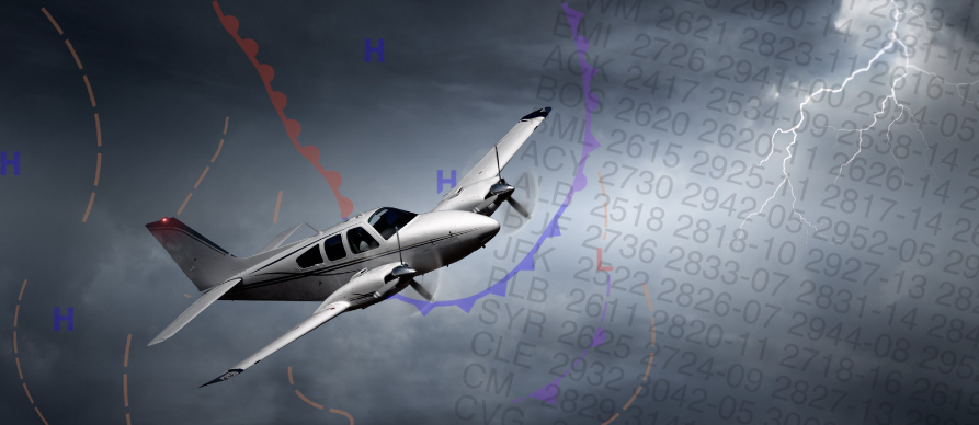
Aviation Routine Weather Report / Meteorological Aerodrome Report (METAR)
METARS (Meteorological Aerodrome Report) are aviation weather observations taken at designated reporting sites throughout the United States. They depict the actual current weather conditions at the reporting location. Normally the observation sites are located on airports, but occasionally outside of the airport boundaries. METAR observations are usually taken and transmitted hourly at about 50 minutes past each hour.
A SPECI (Special Weather Report) is a weather observation that updates a previous METAR (Meteorological Aerodrome Report) when there are significant changes in weather conditions that could affect flight operations. These updates are issued in between the regular METAR reports to ensure that pilots and other aviation personnel have the most current and relevant weather information. Here are some of the conditions that might trigger a SPECI:
- Significant changes in wind speed or direction
- Changes in visibility, especially when it drops below certain thresholds
- Onset, cessation, or change in the intensity of precipitation
- Changes in cloud cover, particularly the appearance or disappearance of low clouds or cumulonimbus clouds
- Occurrence of significant weather phenomena such as thunderstorms, tornadoes, or volcanic ash
- Changes in temperature or dew point that are significant for aviation operations
- Any other phenomena that could affect flight safety
SPECI reports follow the same format as METARs but are issued as needed rather than at regular intervals.
A typical METAR report contains the following information in sequential order:
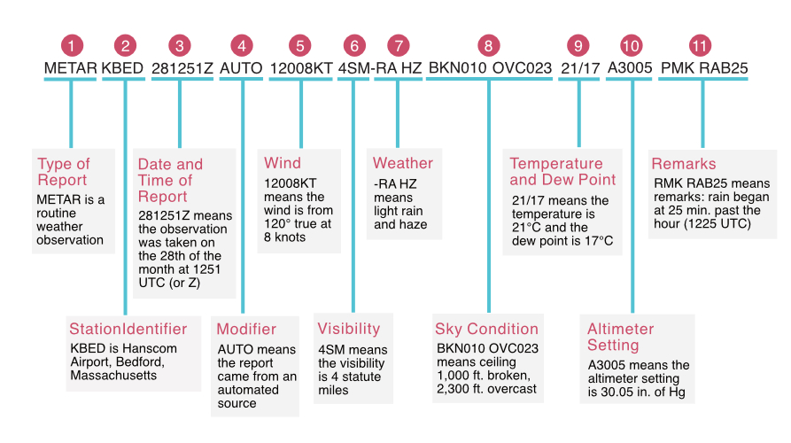
1. Type of report—there are two types of METAR reports. The first is the routine METAR report that is transmitted every hour. The second is a special report, a SPECI, that can be given at any time there is a significant change to the weather reported in the previous METAR.
2. Station identifier A four-letter code. This is, a unique three-letter identifier is preceded by the letter “K.”
For example, Hanscom Airport, is identified by the letters “KBED,” K being the USA country designation and BED being the airport identifier.
3. Date and time of report Depicted in a six-digit group (161753Z). The first two digits are the date, the 16th of the month, and the last four digits are the time of the METAR, which is always given in coordinated universal time (UTC), otherwise known as Zulu time.
4. Modifier — denotes that the METAR came from an automated source or that the report was corrected. If the notation “AUTO” is listed in the METAR, the report came from an automated source. When the modifier “COR” is used, it identifies a corrected report sent out to replace an earlier report that contained an error
5. Wind—reported with five numbers (12008), unless the speed is greater than 99 knots, in which case the wind is reported with six numbers. (if you see six numbers, you probably don’t want to be flying on that day!) The first three numbers indicate the direction from which the wind is blowing to the nearest ten degrees in relation to TRUE North. If the wind is variable, then “VRB” will go after the numbers. The last two digits indicate the speed of the wind in knots, unless the wind is greater than 99 knots, in which case it is indicated by three digits. If the winds are gusting, the letter “G” follows the wind speed numbers, and then the numbers right after G indicate the highest expected wind gusts (example = G26).
6. Visibility—the prevailing visibility (4 SM) is reported in statute miles as denoted by the letters “SM.” It is reported in both miles and fractions of miles. for example ¾ of a mile.
7. Weather —there are three parts to the weather section. The first is a qualifier of intensity. The intensity may be light (-), moderate ( ), or heavy (+). Because we’re seeing a – symbol, that indicates light. Then, if there’s any kind of weather phenomena that’s in the immediate vicinity of the airport, that’ll be shown.
If you happen to see a notation of “VC” in this section, that indicates a specific weather phenomenon is in the vicinity of five to ten miles from the airport. And then finally, the third part of this weather section are the descriptors, which are used to describe certain types of precipitation and obscurations..
8. Sky condition — here we’re getting a sense of what cloud cover looks like. In this first part, we’re seeing the height of the cloud base, which is being reported with a three-digit number in hundreds of feet above-ground-level (AGL).
- BKN stands for broken clouds, and “010” means 1000 feet. So the cloud base is at 1000 feet AGL. That’s one thing that’s happening.
- OVC, stands for overcast, and the “023” stands for 2,300 ft. So we have overcast clouds at 2,300 ft. AGL. The type of cloud is reported here too. CB stands for cumulonimbus clouds, and another indicator you might see here is TCU, which stands for towering cumulus clouds.
9. Temperature and dew point —the air temperature and dew point are always given in whole degrees Celsius (°C) and separated by a forward slash (/). Temperatures below 0°C are preceded by the letter “M” to indicate minus.
10. Altimeter setting—A3005 means that the altimeter should be set the altimeter pressure to 30.05 Hg, or inches of mercury.
11. Remarks—the remarks section always begins with the letters “RMK.” Comments may or may not appear in this section of the METAR. The information contained in this section may include wind data, variable visibility, beginning and ending times of particular phenomenon, pressure information, and various other information deemed necessary. In the above example, PRESFR means “pressure falling rapidly”. Another example of a remark regarding weather phenomenon that does not fit in any other category would be: OCNL LTGICCG. This translates as occasional lightning in the clouds and from cloud to ground. Automated stations also use the remarks section to indicate the equipment needs maintenance.
(Note: When providing wind information to departing or arriving aircraft, Terminal facilities will provide winds relative to magnetic North).
Codes for descriptors and intensity indicators
| Intensity | Descriptor | Precipitation | Obscuration |
| (-) Light (No prefix) Moderate (+) Heavy | MI: Shallow BC: Patches DR: Low drifting BL: Blowing SH: Showers TS: Thunderstorm FZ: Freezing PR: Partial | DZ: Drizzle RA: Rain SN: Snow SG: Snow Grains IC: Ice crystals PL: Ice pellets GR: Hail GS: Small hail or Snow pellets UP: Unknown precipitation | BR: Mist FG: Fog FU: Smoke VA: Volcanic ash DU: Widespread dust SA: Sand HZ: Haze PY: Spray |
| Code | Meaning |
| SKC (Manual report) or CLR (Automated report) | Clear |
| FEW | Few (1/8 to 1/4 of the sky covered) |
| SCT | Scattered (3/8 to 1/2 of the sky covered) |
| BKN | Broken (5/8 to 7/8 of the sky covered) |
| OVC | Overcast (Total sky coverage) |