Surface aviation weather observations (METARs) are a compilation of elements of the current weather at individual ground stations across the United States. The network is made up of government and privately contracted facilities that provide continuous up-to-date weather information.
The information gathered for the surface observation may be from a person, an automated station, or an automated station that is updated or enhanced by a weather observer. In any form, the surface observation provides valuable information about individual airports around the country. Although the reports cover only a small radius, the pilot can generate a good picture of the weather over a wide area when many reporting stations are viewed together.
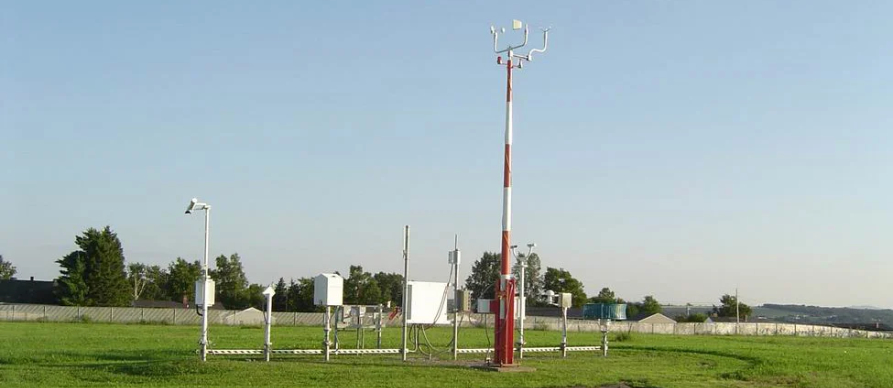
Automated observations are derived from instruments and algorithms without human input or oversight. In the United States, there are two main kinds of automated observing systems:
- Automated Weather Observing Systems (AWOS),
- Automated Surface Observing Systems (ASOS),
Detailed information on ASOS and AWOS can be found in the Aeronautical Information Manual (AIM), Chapter 7, Safety of Flight, Section 1, Meteorology.
Note: Automated METARs and SPECIs contain AUTO in the report
Surface observations provide local weather conditions and other relevant information for a specific airport. This information includes:
- The type of report,
- Station identifier,
- Date and time,
- Modifier (as required),
- Wind,
- Visibility,
- Runway visual range (RVR),
- Weather phenomena,
- Sky condition,
- Temperature/dew point,
- Altimeter reading,
- Applicable remarks.
The functional differences between AWOS and ASOS are often of minimal significance to the aviation community. However, AWOS is typically an FAA-certified weather station operated by state, local, or private entities.
In contrast, ASOS equipment is a collaborative effort involving the National Weather Service, FAA, and Department of Defense in the US. Both systems are meticulously designed to cater to the specific needs of aviation operations.
Both AWOS and ASOS systems imply a particular set of instruments. AWOS systems can be classified from AWOS I (one) to AWOS IV (four) Z/R. Each system incrementally adds more instruments. AWOS I starts with wind, pressure, temperature, and humidity instruments. Visibility, cloud ceiling, precipitation type, lightning, freezing rain, and runway condition sensors are added with each variant.
AWOS – Automated Weather Observing Systems
AWOS Is an automated weather reporting system consisting of various sensors, a processor, a computer-generated voice subsystem, and a transmitter to broadcast weather data.
AWOS is similar to ASOS (Automated Surface Observing System), AWOS is managed by the FAA – whereas the ASOS systems are managed by the National Weather Service (NWS) and tends to provide more comprehensive weather data. AWOS is often operated by state or local aviation authorities.
Types of AWOS Systems:
- AWOS-A: Provides altimeter settings.
- AWOS-AV: Adds visibility to AWOS-A.
- AWOS-1: Measures wind, temperature, and dew point.
- AWOS-3: Includes sky conditions and visibility.
- AWOS-4: Adds precipitation identification and freezing rain detection.
Data Transmission:
- Broadcast via radio frequencies.
- Available through telephone or digital formats for remote access..
AWOS frequencies. Can be found on the aviation sectional charts and terminal area charts along with the airport information contained in the chart supplement (CS)

Automated Surface Observing Systems
ASOS It is a system used to automatically collect and report weather data at airports and other locations. ASOS provides real-time information on various weather parameters, which are crucial for flight planning and safety. The data typically includes:
- Wind speed and direction
- Temperature
- Humidity
- Pressure
- Cloud cover and visibility
- Precipitation
- Sky conditions
- Dew point
ASOS systems are often installed at airports, and the information is available to pilots.
ASOS helps improve situational awareness and decision-making by providing accurate, real-time weather observations, which are essential for safe takeoffs, landings, and in-flight operations.
ASOS frequencies. Can be found on the aviation sectional charts and terminal area charts along with the airport information contained in the chart supplement (CS)

Using ASOS / AWOS when landing at a on towered airport.
In the same way as pilots must listen to ATIS before departing or land into a towered (Class D) airport, pilots must listen to the AWOS and ASOS broadcasts when operating at an un-towered airport as an essential step in maintaining situational awareness, particularly regarding weather conditions.
Checking the ASOS (Automated Surface Observing System) or AWOS (Automated Weather Observing System) when flying into an un-towered airport is a crucial part of gathering weather information for a safe approach and landing. Here’s the procedure:
1. Locate the ASOS/AWOS Frequency or Phone Number
- Find the frequency for the airport’s ASOS/AWOS in the Chart Supplement (CS), on sectional charts, or in your electronic flight bag (EFB).
- If you can’t receive the broadcast in-flight, you can often call the ASOS/AWOS by phone before departure or during a stop. The phone number is also listed in the chart supplement
2. Monitor the ASOS/AWOS Broadcast
- Tune the ASOS/AWOS frequency on your radio as you approach the airport, usually within 25-50 NM, depending on terrain and altitude.
- Listen to the broadcast for current conditions like wind direction and speed, altimeter setting, visibility, sky conditions, and temperature.
3. Update Altimeter Setting
- Adjust your altimeter to match the barometric pressure provided by the ASOS/AWOS. This ensures your altitude readings are accurate during approach.
4. Plan Based on Weather Information
- Determine the most suitable runway based on wind direction.
- Consider visibility and cloud ceiling for the type of approach you plan to execute (e.g., VFR vs. IFR).
5. Announce Intentions on the CTAF/Unicom
- After listening to the ASOS/AWOS, announce your position and intentions on the CTAF/Unicom frequency to coordinate with other traffic.
- For example:
“Traffic at [Airport Name], Cessna 123AB, 10 miles to the west, inbound for landing, Runway 32, [Airport Name] traffic.”
6. Use Caution in Dynamic Weather Conditions
- If conditions change rapidly, recheck the ASOS/AWOS frequency as you approach.
- Stay alert for other pilots announcing conflicting wind reports or other hazards.
7. Alternate Sources if ASOS/AWOS is Unavailable
- If the airport’s ASOS/AWOS is down or unreachable, check nearby airports with operational ASOS/AWOS.
- Cross-reference information from in-flight weather services like ATIS from larger nearby airports or en route weather advisories.