
A cross country flight is defined in FAR 61.1 as:
- A flight between two airports that includes a point of landing that was at least a straight-line distance of more than 50 nautical miles from the original point of departure;
- Involves the use of
- Pilotage
- Dead reckoning,
- Electronic navigation aids, (such as radio aids, GPS or other navigation systems) to navigate to the landing point.
Objective of cross-country flight training
The objective of cross-country (XC) flying is to fly from one airport location to another, typically over long distances, using a variety of navigation techniques and skills. It is a key skill for pilots to master, and forms part of the aeronautical experience requirements for the Private Pilot Practical Test.
A typical cross-country flight will take you from your intended departure airport to another airport, typically navigating through various airspace types, terrain, and possibly multiple weather conditions. Cross-country flying helps pilots become familiar with different types of airspace, such as controlled, uncontrolled, restricted, and special use.
For initial flight training purposes, the FAA requires that you have a certain amount of “aeronautical experience” that you need to complete before you are eligible to take the private pilot practical test (check ride). The minimum aeronautical requirements required to be eligible to take the private pilot practical test (check ride) are:
- 3 hours of cross-country dual (with a flight instructor) flight (ASEL) (FAR 61.109)
- 5 hours solo cross-country flight time (ASEL) (FAR 61.109)
These requirements provide the opportunity to learn and practice essential training and practical flying experience, allowing pilots to build cross country flight planning, navigation and communication skills.
Building Pilot Experience
- Flight Hours: A cross-country flight allows a pilot to log significant flight hours, which is essential for meeting the requirements of various pilot certificates and ratings (Private Pilot, Commercial Pilot, Instrument Rating, etc.).
- Navigation Skills: Cross-country flights require the pilot to use different navigational techniques, including VOR (Very High Frequency Omni-Directional Range), GPS, and dead reckoning.
- Communication Practice: Pilots gain experience communicating with various Air Traffic Control (ATC) facilities (towered, non-towered, center, approach).
Required Flight Planning Skills
- Route Planning: Selecting the optimal route, considering weather, terrain, airspace, and other factors.
- Fuel Management: Calculating fuel consumption, reserves, and refueling stops.
- Weather Analysis: Evaluating and adjusting for weather conditions en route.
- Risk Management: Analyzing all aspects of the proposed flight and highlighting (and mitigating) any risks that may be associated with the flight.
- Aeronautical Decision Making (ADM) a systematic process used by pilots to make sound and timely decisions during flight operations. It’s a key component of risk management and safety, designed to help pilots avoid or minimize risks by making informed decisions based on structured reasoning, experience, and available information.
- Pilots experience varying airport operations, such as large international airports or smaller municipal airstrips.
- Exposure to different weather systems and terrain features enhances the pilot’s decision-making skills.
Operational and Logistical Experience
- Filing Flight Plans: Cross-country flights often require flight plans, giving pilots experience with submitting and managing flight plans.
- Alternate Airports: Learning how to select and use alternate airports in case of weather changes or fuel issues.
Meeting End Goals (Destination)
- While the purpose of training is critical, cross-country flights also provide the opportunity for pilots to reach a specific destination, such as a business trip, vacation, or simply the adventure of flying to a new location.
Cross-country flights are one of the basic aims for a pilot – to travel to destinations other than the airport you departed from. Learning the skill and gaining the experience of cross country flying is essential for a pilot to be able to fly safely and competently over long distances, in unfamiliar areas, and under diverse flying conditions.
Cross Country Flight Planning
The steps to planing a cross country flight
Planning a cross-country flight involves several key steps to ensure that a cross country flight is properly planned for a safe and smooth journey.
1. Define Your Route and Objectives
Begin by identifying your departure airport and destination airport including the intended route of flight between the two points. This is not always just a straight line between two points. Factors must be considered included:
- Destination and intermediate stops: Decide on your destination and any planned stops along the way. Depending on factors such as distance and fuel considerations you may need to make one or more stops prior to reaching your destination airport.
- Flight Path: Choose a route and altitude that considers
- Airspace. Know what airspace your cross country flight will begin from, take you through (and near) and terminate at. Ensure you understand the entry requirements for all airspace’s you will be flying in and ensure you have the required equipment for the airspace(s) you will be flying in.
- Terrain or obstacles. Does the terrain or other obstacles allow you to fly on your proposed route and altitude? Is there a mountain range, or wide expanses of water you would have to cross to reach your destination?
- Restrictions. Consider restrictions that may apply to your flight such at Temporary Flight Restrictions (TFRs), Prohibited Airspace, Restricted Airspace, etc.
- NOTAMs. Notices to Air Missions must be checked for information that may effect the route of your flight or airports you plan to fly from and to.
- Weather.
- Fuel stops (if necessary).
- Route of flight: – When planning the route of your flight take into consideration
- Departure airport
- Climb, (including top of climb – TOC)
- Cruise, (at the correct VFR cross country altitude)
- Route of flight (including appropriate checkpoints on the route)
- Descent, (including top of descent – TOD)
- Arrival at destination of flight.
- Emergency Plan: Always plan for the possibility for the need to divert while enroute.
- Arrival procedures: Be aware of any airport arrival procedures (at both towered and un-towered airports). Be aware of any local traffic pattern operations that you will need to adhere to (review).
- Return Trip: Make sure that you adequately planning for the return leg of the trip.
2. Check Aircraft Suitability
- Aircraft Performance: Ensure your aircraft is suitable for the distance, including range, fuel capacity, and weather handling.
- Maintenance: Confirm that the aircraft is in good condition and has undergone recent maintenance checks.
- Currency and Proficiency: You must authorized and both current and proficient in the aircraft you plan to fly your cross country in.
3. Obtain Necessary Documentation
- Flight Plan: File a flight plan with the appropriate aviation authorities if required.
- Weather Briefing: Get a comprehensive weather briefing for your route, including wind, temperature, and potential hazards.
- Endorsements: Ensure you have the necessary endorsements for solo cross-country flying as a student pilot. As a student pilot you wi
4. Plan Your Fuel Stops
- Fuel Availability: Identify airports along your route where you can refuel if your aircraft’s range is limited.
- Fuel Consumption: Calculate the fuel needed for each leg of the trip, considering reserves for unforeseen delays.
- Know the regulations regarding the amount of fuel and the fuel reserves you are required to have for cross country flights. FAR 91.151
Day VFR fuel minimum regulations
- You must be carrying enough fuel to fly to the first point of intended landing (considering wind and forecast weather conditions) assuming normal cruising speed ..
- Sufficient fuel to fly to fly after that for at least 30 minutes.
Most pilots consider a one-hour reserve to be the minimum for a cross-country flight.
Don’t forget to change over fuel tanks regularly in a Piper Warrior.
Order fuel if you require it!
Night VFR fuel minimum regulations
- You must be carrying enough fuel to fly to the first point of intended landing (considering wind and forecast weather conditions) assuming normal cruising speed ..
- Sufficient fuel to fly to fly after that for at least 45 minutes.
5. Review Airspace and Regulations
- Airspace Restrictions: Be aware of controlled airspace, restricted areas, and any temporary flight restrictions (TFRs).
- Regulations: Ensure you comply with regulations regarding altitude, communication, and navigation.
6. Prepare Navigation Aids
- Charts: Obtain updated navigation charts for your route, including en-route charts, approach plates, and any relevant airport information.
- GPS and Instruments: Verify that your navigation instruments and GPS are functioning correctly.
7. Create a Flight Plan
- Route: Plot your route on a flight plan form, including waypoints and estimated times.
- Weather: Integrate weather information into your plan, noting any potential issues.
8. Safety Considerations
- Emergency Procedures: Review emergency procedures and ensure you have necessary safety equipment.
- Health and Rest: Plan rest breaks if you’re flying long distances or with a crew.
9. Communications
- ATC Communication: Ensure you’re familiar with communication frequencies and procedures for each segment of your flight.
- Radio Equipment: Test your radio equipment before departure to confirm it’s working properly.
10. Final Preparations
- Pre-Flight Inspection: Conduct a thorough pre-flight inspection of the aircraft.
- Passenger Briefing: If you’re flying with passengers, brief them on safety procedures and expectations.
11. Monitor and Adjust
- In-Flight Monitoring: Continuously monitor weather conditions, air traffic, and aircraft performance.
- Adjust Plans: Be prepared to adjust your route or make changes based on real-time conditions.
12. Arrival Procedures
- Approach and Landing: Plan your approach and landing, considering the airport’s procedures and any changes in weather conditions.
- Post-Flight Checks: Perform post-flight checks and ensure the aircraft is secured.
Each flight is unique, so adapt these steps based on your specific needs and circumstances.
Elements of Cross Country Flight Planning
FAR 91.103 states: “Each pilot in command shall, before beginning a flight, become familiar with all available information concerning that flight.“
It is essential that prior to any flight that leaves the vicinity of the airport, including all cross-country flights that the required pre-flight planning actions, data collection and the factors going into the decision to fly the planned route are satisfied.
Pilots should use NWKRAFT as a guide and checklist to collect all required cross country information.
NWKRAFT is an acronym used by pilots to remember crucial preflight action items (14 CFR 91.103), which are critical information that pilots should be familiar with before a flight.
NWKRAFT items
- NOTAMS,
- Weather, (including winds aloft)
- Known ATC Delays,
- Runways (lengths and alignment)
- Alternatives (in event of needing to divert)
- Fuel Requirements (Estimate likely time and fuel burn)
- Takeoff and Landing Distances
- Be aware of and utilize cross-country flight procedures
- Use the specific cross-country flight communications including flight following.
- Plan for a diversion if unable to land at intended destination airport or plan to change procedures including chance of getting lost if checkpoints are not monitored.
- Airport arrival procedures (towered and un-towered).
- Be aware of traffic pattern operations at departure and destination airports (Chart Supplement).
- Pilots should plan for the outbound and return the return leg of the trip.
- Student pilots should specify each step to ensure instructor is aware of what they are thinking for the plan.
Planning a Cross Country Flight Example –
Hanscom (KBED) to Northampton (7B2)
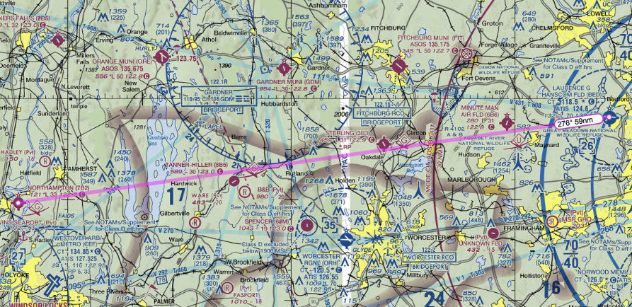
- From: Hanscom Field, Bedford, MA (BED)
- To: Northampton. MA (7B2)
Tools you will need for flight planning
Sectional Chart(s)
- Paper New York sectional chart
- Electronic planning tools
Chart Supplement
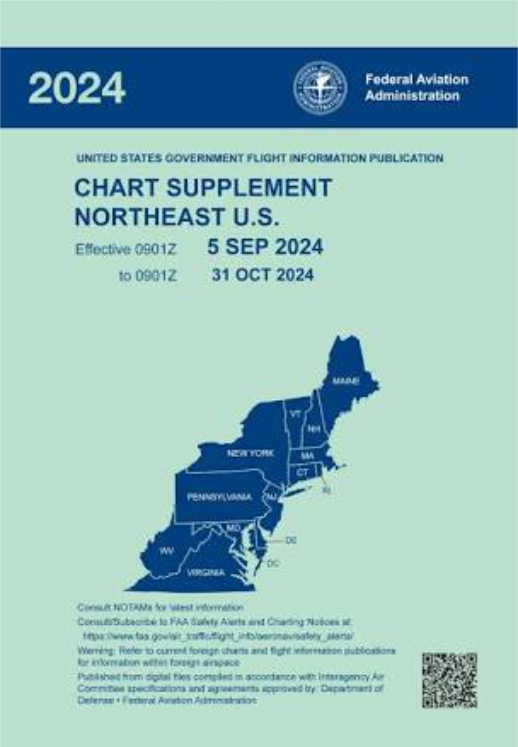
A Chart Supplement is a publication providing updates and additional information that supplement the standard aeronautical charts used for navigation.
The Chart Supplement is issued regularly, often quarterly or semi-annually. Ensure you have the most current version – this is crucial for ensuring you have up to date and accurate information for your flights.
Plotter
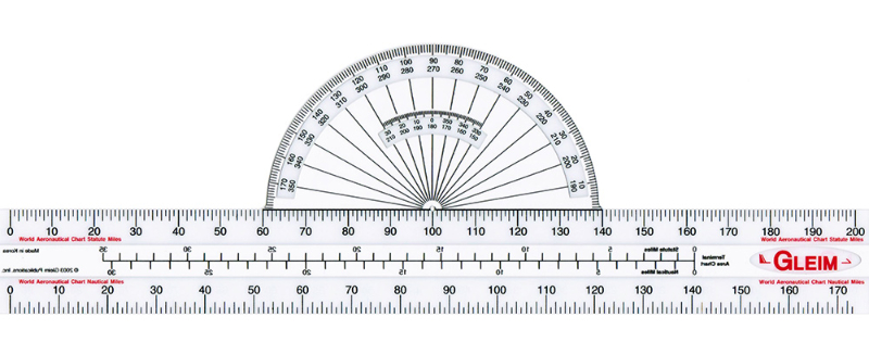
An aviation plotter is a navigation tool used primarily by pilots and aviation enthusiasts to assist in flight planning and navigation. It is typically a clear plastic ruler with various scales and grids to help with measuring distances and angles on aeronautical charts.
E6B calculator (mechanical or electronic)
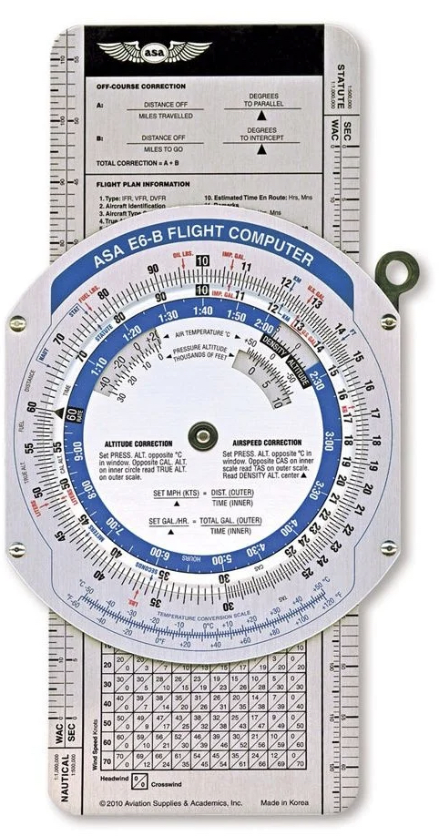
The E6B flight computer, often referred to as a “whiz wheel,” is a critical tool used by pilots for flight planning and in-flight navigation. It allows for quick calculations of various flight parameters such as fuel consumption, ground speed, time en route, and wind correction. The E6B is a versatile device that combines analog and digital elements, making it highly reliable even without electronic power
Four function calculator

A 4-function calculator is a basic, yet essential, device for performing simple arithmetic operations. It includes the four primary functions: addition, subtraction, multiplication, and division. These calculators are commonly used in educational settings and for everyday calculations.
Pencil

Any regular graphite pencil is will work for flight planning. The advantage is that you may mark your charts and documents and erase the marks if you make a mistake or change plans. A wooden pencil or mechanical pencil are both acceptable choices. It is advisable to have an eraser available if the pencil does not have one attached.
VFR Navigation Log (Nav Log)
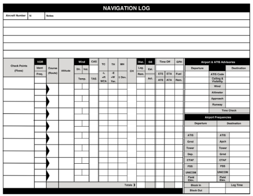
Aviation flight planning sheets – navigation log sheets, also known as flight logs or nav logs, are essential tools used to plan and track flights.
These logs help ensure accurate navigation, fuel management, and overall flight safety. They provide a structured format for recording critical information before and during a flight.
Formulating the plan – (the plan for the plan)
- Identify the departure and destination on the chart.
- Mark the desired route between the departure and destination airport.
- Check the chart for terrain and airspace, altitudes, navigation aids, identify potential landing places in case of an emergency.
- Mark checkpoints along the route of flight – on the chart.
- Research airport information in the chart supplement publication.
- Enter information into the VFR navigation log – fill out as much as you possibly can.
- Departure, Destination, enter all the checkpoint along the course:
- Planned use of NAVAIDS (VOR, GPS, Flight Following)
- Determining headings, speeds, and course
- Winds / Winds aloft / wind correction angle(s)
- Estimate times, speeds, and distances
- Power setting selections
- Fuel burn calculations
- Planned versus actual flight plan calculations and required corrections
- If using FOREFLIGHT or other app, ensure you are familiar with the technology before attempting to use in flight / cross country.
- Check NWKRAFT items
- NOTAMS
- Weather, (including winds aloft)
- Known ATC Delays,
- Runways (lengths and alignment)
- Alternatives (in event of needing to divert)
- Fuel Requirements (Estimate likely time and fuel burn)
- Takeoff and Landing Distances
- Verify airplane weight and balance
- Verify sufficient performance for takeoff and landing on suitable runways (allowing for weather)
Collision Avoidance
- Fly at expected VFR altitudes – be predictable!
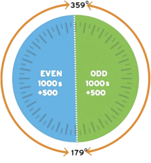
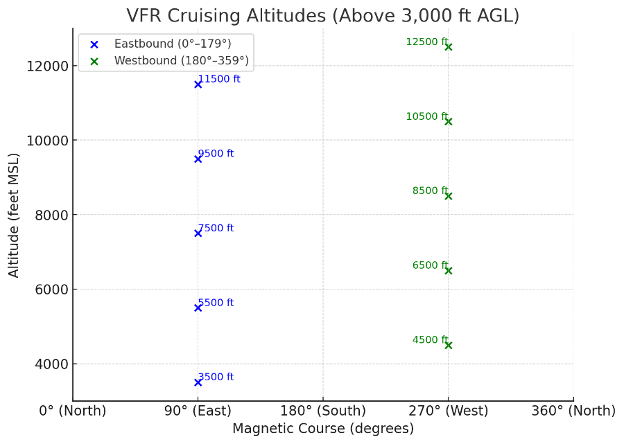
- When flying VFR (Visual Flight Rules) cross-country, pilots must adhere to specific altitude rules to ensure safety and compliance with regulations. These altitudes are determined by the type of airspace and direction of flight. Here’s a summary of the key altitude rules for VFR cross-country flights:
- Below 3,000 feet AGL: Maintain an altitude that provides a clearance of 1,000 feet above any obstacle within a horizontal distance of 2,000 feet.
- Above 3,000 feet AGL:
- Magnetic Course 0° to 179°: Fly at odd thousand-foot altitudes plus 500 feet (e.g., 3,500 feet, 5,500 feet).
- Magnetic Course 180° to 359°: Fly at even thousand-foot altitudes plus 500 feet (e.g., 4,500 feet, 6,500 feet).
Right of way rules: FAR 91.113
- Aircraft in distress have the right of way over all other aircraft
- When towing or refueling another aircraft has the right of way over all engine driven aircraft
- Use Technology: If you have a traffic awareness technology such as ADS-B, include it in your scan and practice correlating targets on the screen to what you see out the windscreen. Technology can improve your situational awareness, but it’s not a substitute for looking outside: Don’t fixate on the screen, and remember not all aircraft will appear on the display.
- Use aircraft lights as required – to be seen.